File:Rökstenen - KMB - 16000300014288.jpg

Size of this preview: 800 × 534 pixels. Other resolutions: 320 × 213 pixels | 640 × 427 pixels | 1,024 × 683 pixels | 1,280 × 854 pixels | 2,965 × 1,978 pixels.
Original file (2,965 × 1,978 pixels, file size: 5.62 MB, MIME type: image/jpeg)
| This free media file is from Wikimedia Commons. Its description page is included below. |
| Rökstenen
( |
|||||||||||||||||||||||||||
|---|---|---|---|---|---|---|---|---|---|---|---|---|---|---|---|---|---|---|---|---|---|---|---|---|---|---|---|
| Photographer |
|
||||||||||||||||||||||||||
| Title |
Rökstenen |
||||||||||||||||||||||||||
| Original caption |
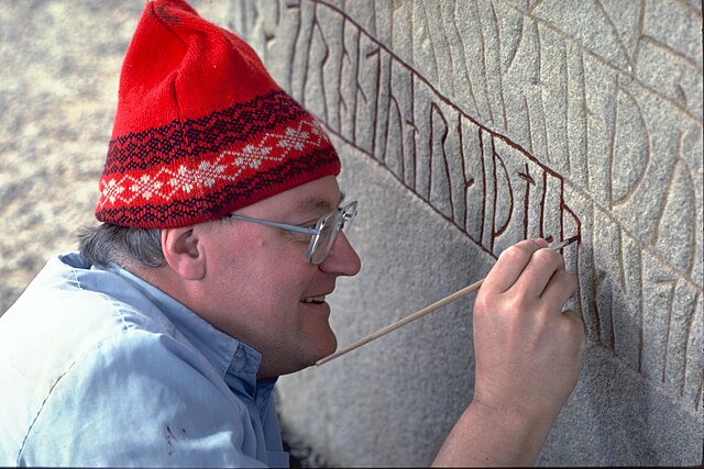
Notera Av dokumentationsskäl har originalbeskrivningen från Riksantikvarieämbetet behållits. Tillrättalägganden och alternativa beskrivningar bör införas separat från nedanstående information. Imålning av runorna på Rökstenen.Felaktigheter kan även anmälas till denna sida. Motiv: Ög136 Rök |
||||||||||||||||||||||||||
| Description |
Imålning av runorna på Rökstenen av Helmer Gustavson. Ög136 Rök.
|
||||||||||||||||||||||||||
| Depicted place | Sweden, Ödeshög Municipality, Rök | ||||||||||||||||||||||||||
| Date | 1 May 1986 | ||||||||||||||||||||||||||
| Collection |
|
||||||||||||||||||||||||||
| Accession number | |||||||||||||||||||||||||||
| Source |
Bengt A Lundberg / Kulturmiljöbild, Riksantikvarieämbetet
|
||||||||||||||||||||||||||
| Permission (Reusing this file) |
This file is licensed under the Creative Commons Attribution 2.5 Generic license. Attribution: Bengt A Lundberg / Riksantikvarieämbetet
|
||||||||||||||||||||||||||


| Object location | | View this and other nearby images on: OpenStreetMap |
|---|
File history
Click on a date/time to view the file as it appeared at that time.
| Date/Time | Thumbnail | Dimensions | User | Comment | |
|---|---|---|---|---|---|
| current | 15:24, 10 November 2021 | | 2,965 × 1,978 (5.62 MB) | VulpesVulpes42 | Högre upplösning. |
| 21:58, 9 June 2017 |  | 768 × 512 (51 KB) | AndreCostaWMSE-bot | {{Kulturmiljöbild-image | short title = Rökstenen | original description = Imålning av runorna på Rökstenen.<br> Motiv: Ög136 Rök<br> Nyckelord: Raä-Fastigheter, Runor<br> Kategori: Arbetsmotiv, Runristning/runsten | wiki description = Imålnin... |
File usage
The following 2 pages use this file:
Global file usage
The following other wikis use this file:
- Usage on en.wikipedia.org
- Usage on es.wikipedia.org
- Usage on fr.wikipedia.org
- Usage on no.wikipedia.org
- Usage on sv.wikipedia.org
- Usage on www.wikidata.org